


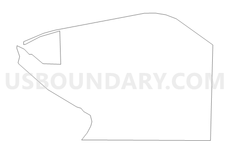
Dot Voting District, Benton County, Washington
About
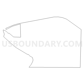
Outline
Summary
| Unique Area Identifier | 683498 |
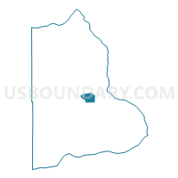
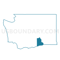
| Name | Dot Voting District |
| County | Benton County |
| State | Washington |
| Area (square miles) | 12.67 |
| Land Area (square miles) | 12.67 |
| Water Area (square miles) | 0.00 |
| % of Land Area | 100.00 |
| % of Water Area | 0.00 |
| Latitude of the Internal Point | 46.23732090 |
| Longtitude of the Internal Point | -119.41304180 |
Maps

Graphs
Select a template below for downloading or customizing gragh for Dot Voting District, Benton County, Washington


Neighbors
Neighoring Voting District (by Name) Neighboring Voting District on the Map
- Benton East Voting District, Benton County, WA
- Benton West Voting District, Benton County, WA
- Cone Voting District, Benton County, WA
- Cook Voting District, Benton County, WA
- Griffin Voting District, Benton County, WA
- Kiona Voting District, Benton County, WA
- Reese Voting District, Benton County, WA
- Wellington Voting District, Benton County, WA
Top 10 Neighboring County Subdivision (by Population) Neighboring County Subdivision on the Map
- Richland-Kennewick CCD, Benton County, WA (154,811)
- Northwest Benton CCD, Benton County, WA (13,622)
Top 10 Neighboring Place (by Population) Neighboring Place on the Map
Top 10 Neighboring Unified School District (by Population) Neighboring Unified School District on the Map
Top 10 Neighboring State Legislative District Lower Chamber (by Population) Neighboring State Legislative District Lower Chamber on the Map
Top 10 Neighboring State Legislative District Upper Chamber (by Population) Neighboring State Legislative District Upper Chamber on the Map
Top 10 Neighboring 111th Congressional District (by Population) Neighboring 111th Congressional District on the Map
Top 10 Neighboring Census Tract (by Population) Neighboring Census Tract on the Map
- Census Tract 118, Benton County, WA (6,546)
- Census Tract 108.14, Benton County, WA (2,844)
- Census Tract 108.07, Benton County, WA (1,082)